La Plata, 14,336 ft.
Follow the dirt road south and turn left onto good trail. The stream near the Lake Creek (north) trailhead is contaminated with poisonous metals and cannot be treated by boiling, filtering, or tablets. The trail becomes poor and rocky near the summit.
Descend SW across boulders and tundra to a notch in the ridge at 12,800 ft. where you will find a steep trail descending SE into the marshy basin. Most maps incorrectly show the trail descending from higher up on the ridge. The trail through the marsh is very wet. Descend downhill on trail and jeep road into the aid station at Winfield (crew reachable by car).
Huron, 14,003 ft.
The new trail on the west side is not on some maps, but has good footing. The east side is difficult. Return to the saddle north of Huron and descend down a very steep slope and cross a boulder field. Descend steeply again through willows, then pick up a trail at treeline 200 yards north (left) of Lois Lake. The trail descends to the downstream (north) side of Clohesy lake. Cross the stream and follow the trail to the gate at the end of Clohesy Lake jeep road. Go south (uphill) on the closed road to the abandoned cabin at the lake. There might be an aid station here (crew reachable by 4WD and fording a 2 ft. deep stream which may be impassable, then hiking the last 1/4 mile).
Missouri, 14,067 ft.
Follow the trail S on the E side of Clohesy Lake, where it turns left, E, uphill. At treeline the trail disappears. Cross tundra to the NW ridge of Missouri, turn right, and take the rough trail on the ridge to the summit.
You have 3 descent options. The fastest route to the aid station (no crew access) in Missouri Gulch at 12,600 ft. is to descend the scree slopes directly from the summit going NE. There is also a good trail (built in 2001) that switchbacks down, and is the recommended ascent route going south to north. The third choice is to take the 3 class 4 pitches going E to Elkhead Pass at 13,220 ft. and bypass the aid station. The top 3 runners in 2002 ascended this route.
Belford, 14,197 ft.
This is on good trail from Elkhead Pass, and not very steep.
Oxford, 14,153 ft.
Oxford is 1 mile east of Belford. The two mountains are connected by a saddle descending to 13,500 ft.
There is no trail between Oxford and Pine Creek. The marked route descends the south side of the Belford-Oxford saddle across steep but walkable tundra to treeline, then picks up an unmarked trail at treeline, then descends an avalanche chute to the good trail at the Bedrock Falls aid station (no crew access).
Harvard, 14,420 ft.
Cross the stream S, then bushwack uphill to treeline. Go around a cliff face on the right, then up the tundra ridge to the summit. There is some boulder climbing near the top.
From the summit, follow the ridge SE. Leave the ridge E (left) after going around a large pinnacle that looks like a cat's claw, vertical on the left and curved on the right. Descend easy slopes to 12,600 ft. to avoid the boulders. The top of the ridge is class 5.7.
Columbia, 14,073 ft.
Climb, staying left to avoid the rocks until you are above the upper basin, then climb boulders to the summit.
Descend the south ridge, which turns east. Leave the ridge where 3 cairns direct you down the south slopes. Descend tundra at 50% grade, which steepens to a 70% grade below treeline. Bushwack down the avalanche chute to the aid station (no crew access) at the junction of the Horn Fork and Kroenke Lake trails near a footbridge.

Yale, 14,196 ft.
Climb the avalanche chute (bushwacking, 50% grade) south, where you will find aircraft wreckage. Above treeline, climb to a saddle and circle right around the cirque to the summit.
The fastest descent is the Denny Creek trail, then 3 miles of paved road to the Avalanche Gulch aid station (crew reachable by car). The trail is runnable with good footing. When going south to north, a more direct route is up the CO trail to a saddle at treeline and up the east ridge. The ridge is slow and rocky, so not recommended for a fast descent.
Princeton, 14,197 ft.
Take the CO trail to Maxwell Gulch, where you will find an abandoned jeep road climbing steeply SW to your right along the right side of the drainage. Above the trees at 10,600 ft. head for the NE ridge of Princeton, which is on easy tundra once above a short scramble at the bottom. There is one false summit. Avoid going higher in the basin because all routes are on steep, dangerous, loose rocks.
Descend SW over point 13971. Take the S ridge and descend it on the right side into a basin at treeline. Follow the drainage until you find a trail. The trail traverses W into Alpine and is not shown on most maps. The trail reaches 292C, a dirt road going south to the main road, 292 (dirt). Turn right, then 1/4 mile later turn left across a bridge. Turn right for 1/4 mile on 162 to the Baldwin Gulch aid station (crew reachable by car).

Antero, 14,269 ft.
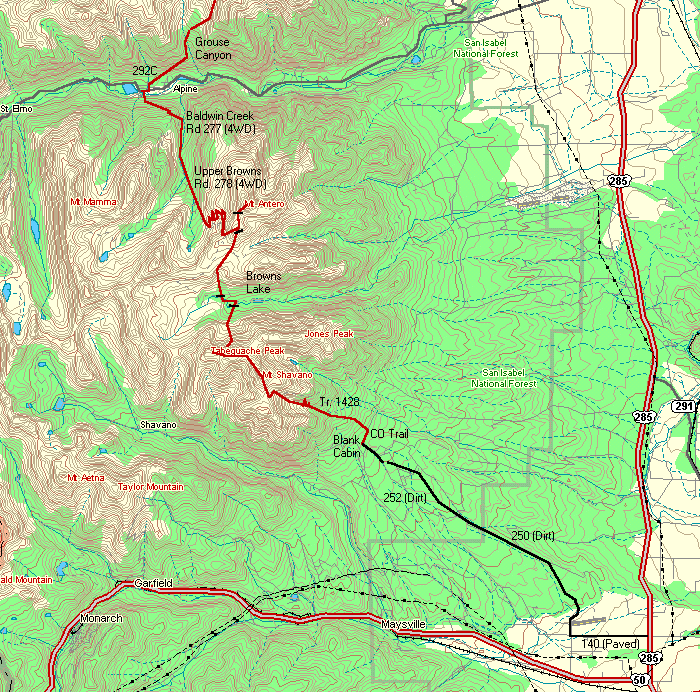
Take the jeep road to 13,800 ft. and the ridge to the summit. Descend the road until you are above the large, flat basin to the south and cross the basin. Descend south down steep slopes back to the jeep road and E until you are just above Brown's Lake.
Tabeguache, 14,155 ft.
Climb S up the drainage to the saddle between Shavano and Tabegauche. Turn right and climb the ridge to Tabeguache.
Shavano, 14,229 ft.
The short traverse from Tabeguache is mostly over boulders. The trail from Shavano to Blank Cabin is quite good and runnable.
Crew/Aid Station Access Points (north to south)
Fish Hatchery (North Start/Finish - Massive)
From Leadville, go south on US. 24 and west on 300 (paved) to Fish Hatchery.Half Moon (Massive - Elbert)
From 300, follow signs south to Half Moon campground. Dirt road becomes rough past treeline (9600 ft). The last 2 miles require easy 4WD. You can camp there.La Plata Trailhead (Elbert - La Plata)
Take Rt. 82 (paved) 14.5 miles west of US. 24, past Twin Lakes, toward Independence Pass. Crewing at Echo Canyon (to Mt. Elbert) is not recommended because of lack of parking.Winfield (La Plata - Huron)
Take Clear Creek Rd (Rt. 390, washboard dirt road) 11.8 miles west from US. 24 to the ghost town of Winfield. Turn left and cross the bridge to the camping area. There is free primitive camping with an outhouse.Rockdale (Huron - Missouri)
Requires 4WD or a 2 mile hike. The Rockdale road is easy to miss. It is 2 miles east of Windfield and 0.4 mi. west of the Colorado Trail north junction to Hope Pass. Pass some cabins and ford Clear Creek, which is normally 18 inches deep, and impassable in wet weather. Drive south to trailhead. Primitive camping.Missouri Gulch (Missouri - Belford)
3.5 mile hike, climbs from 9600 to 12,600 ft. Park at Missouri Gulch (no overnight camping at trailhead). Hike south to the mouth of the stream above treeline and camp.Pine Creek (Oxford - Harvard)
10 mile hike to camp at 11,200 ft. The first part of the trail crosses private property and there is a fee to cross of $1.00 per person and $2.00 per pack animal.North Cottonwood (Columbia - Yale)
From Buena Vista take 350 west (paved) to the T junction, then right, then left onto 365 (dirt) at the second T junction. The last 2-3 miles of dirt road are very rough. Park at the trailhead and hike 2 miles west on the Horn Fork trail to the wooden bridge over Horn Fork Creek and camp just past the bridge. You should have a good view of runners on the avalanche chutes going up Yale and Columbia from here.Avalanche Gulch (Yale - Princeton)
Take Rt. 306 west to the large Avalanche Gulch parking lot on the right. There is primitive camping across the road from the trailhead, or fee camping 2.5 miles west at Collegiate Peaks Campground. You may also go 1 mile further west to the Denny Creek trailhead for runners taking that route on Yale.Baldwin Gulch (Princeton - Antero)
Take Rt. 162 west (paved and smooth dirt) just past Alpine and park at Baldwin Gulch.Blank Cabin (Shavano - South Start/Finish)
From Poncha Springs, take 250 (dirt) and 252 (4 miles rough dirt) to an open field, where the Colorado Trail crosses on the west side. Primitive camping. Alternatively, take 240 north (paved) to Angel of Shavano campground and hike 2 miles north on the Colorado Trail.These maps were produced using DeLorme Topo 2.0 (www.delorme.com). Additional detail was added using Trails Illustrated maps 127, 129, and 130 (which I recommend carrying during the run). I also recommend Colorado's Fourteeners by Gerry Roach for additional maps and route descriptions.
Matt Mahoney matmahoney@yahoo.com